Posts

Single marine charts folio covering UK, Ireland, France and Netherlands

 We are pleased to announce that we now have a unified folio covering UK, Ireland, France and Netherlands .  The folio also includes charts for inland rivers and canal system in UK and Netherlands (including depth maps with HD bathymetry). In addition to coastal charts, we have also incorporated French inland rivers and lake maps. UK Ireland France Netherlands Its already available for Android and iOS. It will be available soon for MacOS and Windows.

Offline i-Boating WMTS (Web Map Tile Service - Marine Charts & Lake Maps)

Image
 We are pleased to announce the availability of i-Boating WMTS , an application supported on Windows &  MacOS.  The i-Boating WMTS is  a dynamic web map tile service that runs on your localhost and provides coverage for marine charts and lake depth maps. Its the most customizable marine WMTS and compatible with QGIS, ArcGIS, ArcGIS online, Grassgis and any software compatible with the OGC WMTS standard. Its the only Marine Charts WMTS that's capable of running offline and more customizable than a chartplotter. Offline support: Designed for private internal use to run on your localhost even when offline Change depth unit to feet, meter or fathom Tile size can be customized to  256, 512 or 1024 Both http and https support For https, add your own SSL certificate or use our bundled self-signed certificate Compatible with most GIS software and web - applications including QGIS, ArcGIS, ArcGIS online, GrassGIS and platforms like Here Maps, Google Maps, javascript...

i-Boating Video Tutorials

 We have created a few video tutorial on using the i-Boating app. The tutorial videos are organized in a playlist.  Youtube Playlist for i-Boating tutorial videos Here is a list of all topics covered in our video tutorials. Download Offline Marine Charts Creating New WayPoints Auto Routing Chart & App Settings Manual Route Editing Marine Weather Forecasts GPS Features (Auto Follow, Record, Route Assistance, Goto WayPoint) The video have been created on iOS (iPhone/iPad).   The steps are similar on Android, Windows & MacOS.

NMEA alarms for depth and wind speed are now available in i-Boating

Image
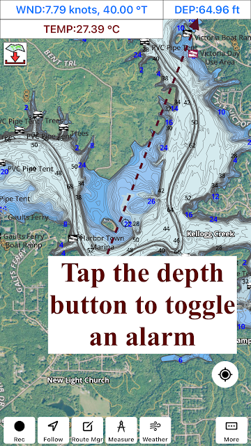
 The latest version of the i-Boating application now lets you set an alarm for depth and wind speed. Its supported on all platforms (iOS, Android, Windows and MacOS). You must have a working NMEA instrumentation set up in the i-Boating application to use these features. Simply tap/click on the blue text/button showing the depth to set the alarms, adjust thresholds etc. I've included below a few screenshots with this feature in action.  

Ontario lakes (Lac Nepewassi) boating and fishing

Image
 i-Boating includes detailed vector charts of inland lakes in Ontario for boating and fishing. Its the largest collection of contour maps for popular Ontario lakes.  All maps can be downloaded for offline use to your device (Windows, MacOS, iOS, Android). Once downloaded you can study lake topography, identify structure and mark potential fishing spots. GPS features are supported on all platforms and work well on all inland lakes without internet connectivity. Lac Nepewassi Depth Map

Australia & New Zealand inland lakes

Image
 We have been working to constantly improve our coverage for inland lakes in Australia and New Zealand. We have prioritized lakes and water bodies that have been requested by our customers. If you have the i-Boating app, please update your maps to get access to the new lakes that have been added. If your favorite lake is still missing, please let us know so that we can  follow up on it. Australia Inland Lakes & Fishing Maps Chart Viewer

Visualize GPX files in the browser over Marine Charts

One of our team members built a GPX file visualizer using the i-Boating Web API . You can  try the viewer yourself at the link below: GPX File Visualizer Simply click on the "Choose File" button on the top. Point it to your GPX File and that's it.